11 results
tagged
map x
-
Carto GRAOU
Carte interactive ferroviaire France en temps réel.Tue Mar 12 14:02:44 2024 - permalink -- https://carto.graou.info/
-
NASA Worldview
This app from NASA's EOSDIS provides the capability to interactively browse over 600 global, full-resolution satellite imagery layers on desktop and mobile devices. Many of the imagery layers are updated within three hours of observation, showing the entire Earth as it is "right now". This supports time-critical applications such as wildfire management, air quality measurements, and flood monitoring. Some satellite imagery layers span almost 30 years, providing a long term view of our dynamic planet. The underlying data is available for download, and Arctic and Antarctic views of several imagery layers are available for a “full globe” perspective.Mon May 21 05:43:28 2018 - permalink -- https://worldview.earthdata.nasa.gov/
-
How To Easily Print A Large Image To Multiple Pages In Windows | Scottie’s Tech.Info
This tip is really great:Thu Mar 3 10:53:58 2016 - permalink -
"You’re going to find this hard to believe, but that built-in Windows app that will split-print an image for you is none other than Microsoft’s much-maligned Paint application!!"
1. Open the image you’d like to print in Paint
2. Select: Print -> Page Setup (Vista and 7), or File -> Page Setup (in XP)
3. Under Scaling, select Fit to and change the setting to something like “2 by 2 page(s)”
4. Click OK
5. Print the image from Paint, and make sure to select “All Pages”- http://scottiestech.info/2009/08/08/how-to-easily-print-a-large-image-to-multiple-pages-in-windows/
-
Spherical Delaunay triangulation, convex hull, Voronoi diagram
An interactive online tool to draw Voronoi diagram on a google mapTue Jan 19 13:13:30 2016 - permalink -- http://lpetrich.org/Science/GeometryDemo/GeometryDemo_GMap.html
-
World Airports Voronoi
Carte Voronoi de tous les aéroports du monde avec des lignes régulièresThu Sep 10 19:29:42 2015 - permalink -- https://www.jasondavies.com/maps/voronoi/airports/
-
The True Size Of...
It is hard to represent our spherical world on flat piece of paper. Cartographers use something called a "projection" to morph the globe into 2D map. The most popular of these is the Mercator projection.Thu Sep 10 19:18:25 2015 - permalink -
Every map projection introduces distortion, and each has its own set of problems. One of the most common criticisms of the Mercator map is that it exaggerates the size of countries nearer the poles (US, Russia, Europe), while downplaying the size of those near the equator (the African Continent). On the Mercator projection Greenland appears to be roughly the same size as Africa. In reality, Greenland is 0.8 million sq. miles and Africa is 11.6 million sq. miles, nearly 14 and a half times larger.- http://thetruesize.com/
-
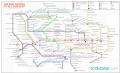
: INAT metro maps
INAT is a mapping standard developed by French Serbian architect Jug Cerovic offering easy to read, easy to memorize and easy to use subway network maps.Mon Apr 14 00:51:18 2014 - permalink -- http://www.inat.fr/
-
VisaMapper
Carte interactive qui permet de voir d'un seul coup d'oeil les pays qui exigent un visa avant votre arrivée, qui n'en demandent pas, qui en propose en ligne ou encore qui en fournissent une fois arrivé à destination, tout ça en fonction de votre nationalité.Mon Jan 6 02:19:54 2014 - permalink -
(via sebsauvage http://sebsauvage.net/links/?68emog via korben http://korben.info/faut-il-un-visa-pour-aller-en.html)- http://www.visamapper.com/
-
 The best movies of all time map
From WTFViz, but still interesting.Tue Oct 29 20:47:13 2013 - permalink -- http://macguffin007.files.wordpress.com/2013/09/250-best-movies-map.jpg
-
Cosmography of the Local Universe
The three-dimensional structure of the local universe may one day become as familiar as our local geography thanks to a new generation of maps that reveal our neighbourhood’s rich complexity and our place within itWed Jun 5 17:30:24 2013 - permalink -
Helene Courtois at the University of Lyon in France and a few buddies show off this newfound knowledge in a movie (and accompanying paper) that they’ve created to explore the rich structure of our galactic neighbourhood.- http://irfu.cea.fr/cosmography
-
New Science of Cosmography Reveals 3D Map of the Local Universe | MIT Technology Review
The three-dimensional structure of the local universe may one day become as familiar as our local geography thanks to a new generation of maps that reveal our neighbourhood’s rich complexity and our place within itWed Jun 5 17:29:27 2013 - permalink -- http://www.technologyreview.com/view/515746/new-science-of-cosmography-reveals-3d-map-of-the-local-universe/

